-
Kamakshi S
22:48 02nd Mar, 2013
Bing Maps Gets A Major Revamp; Shows Off Images From The Ocean Bed | TechTree.com
Bing Maps Gets A Major Revamp; Shows Off Images From The Ocean Bed
Available on the browser-based maps as well as Windows 8 Maps App.
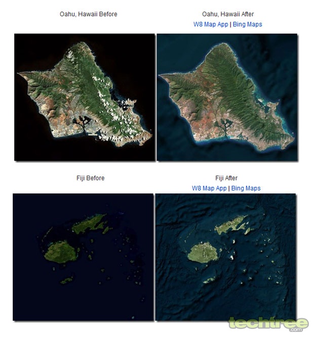
Microsoft is keen to make its presence felt in the ever-so-competitive maps space. In that direction, Bing Maps has just received its biggest update to date, which gives users more detailed insights into the ocean floor. The data has been compiled by the Scripps Institute of Oceanography and satellite imagery comes from TerraColor. One of the noteworthy things that TerraColor brings is the reduced the cloud covers over areas such as the Hawaiian Islands, for instance.
On its official blog, the mapping service is said to have scoured images from the US. Moreover, under it Global Ortho Project, Microsoft now claims to having covered 90% of Western Europe.
Other significant locations covered include Sardarshahar in India, South Georgia and South Sandwich Islands in the United Kingdom, Pitesti in Romania, and Arbil in Iraq.
As for the Bathymetric Shading technique, the blog further explains: "The topography of the ocean floor is represented by color [sic] shading (dark blues to light blues) indicating changes in ocean depth. An ocean mask minimizes areas typically obscured by ice and clouds. The combination of the ocean mask and bathymetric imagery provides a more meaningful view of the world oceans".
Not only online users of Bing Maps but also those using the Windows 8 Maps App can see the changes.

However, Google has been at it for ages now. In fact it has also recreated the Moon and Mars with variants of its Google Earth tool. Is it a bit too late for Bing to enter the arena? Well, I guess better late than never. At least we are sure that the apps work as promised!
- DRIFE Begins Operations in Namma Bengaluru
- Sevenaire launches ‘NEPTUNE’ – 24W Portable Speaker with RGB LED Lights
- Inbase launches ‘Urban Q1 Pro’ TWS Earbuds with Smart Touch control in India
- Airtel announces Rs 6000 cashback on purchase of smartphones from leading brands
- 78% of Indians are saving to spend during the festive season and 72% will splurge on gadgets & electronics
- 5 Tips For Buying A TV This Festive Season
- Facebook launches its largest creator education program in India
- 5 educational tech toys for young and aspiring engineers
- Mid-range smartphones emerge as customer favourites this festive season, reveals Amazon survey
- COLORFUL Launches Onebot M24A1 AIO PC for Professionals


Reader Comments (1)