


-

Kamakshi S
19:12 17th Sep, 2013
How Google Maps Helps To Clear Landmines | TechTree.com
How Google Maps Helps To Clear Landmines
An NPO uses Google's mapping data for landmine clearance in post-conflict areas.
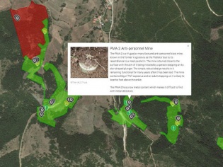
Now in the past, Google Maps have been a part of some interesting stories of human relevance. These go beyond catching a bus/train, or driving to an unknown destination. In a blog post, Google explains how HALO Trust, a UK-based non-profit organisation used Google Maps for Business to clear well over 1.4 million landmines across the world in post-conflict areas.
The company uses Google Maps and Earth Pro along with GPS tracking to warn of explosives buried under the earth, so that it can be neutralised. The video below chronicles the tale of the city of Kosovo, where the conflict ended in 1999, and the company gets information of live mines from the farming communities and locals. Check it out for more details.
News Corner
- DRIFE Begins Operations in Namma Bengaluru
- Sevenaire launches ‘NEPTUNE’ – 24W Portable Speaker with RGB LED Lights
- Inbase launches ‘Urban Q1 Pro’ TWS Earbuds with Smart Touch control in India
- Airtel announces Rs 6000 cashback on purchase of smartphones from leading brands
- 78% of Indians are saving to spend during the festive season and 72% will splurge on gadgets & electronics
- 5 Tips For Buying A TV This Festive Season
- Facebook launches its largest creator education program in India
- 5 educational tech toys for young and aspiring engineers
- Mid-range smartphones emerge as customer favourites this festive season, reveals Amazon survey
- COLORFUL Launches Onebot M24A1 AIO PC for Professionals
TECHTREE