


-

Kamakshi S
12:07 20th Mar, 2013
Peek At Mount Everest And The Kilimanjaro With Google Maps | TechTree.com
Peek At Mount Everest And The Kilimanjaro With Google Maps
Adds four new destinations to its mapping system, with amazing imagery.
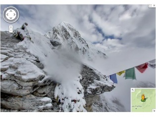
If Bing Maps is busy mapping the depth of the world's oceans, Google seems to taking time off to scale some of the world's highest mountains. The newest destinations include four famed mountain peaks: Aconcagua (South America), Kilimanjaro (Africa), Mount Elbrus (Europe) and Everest Base Camp (Asia).
At the forefront of the initiative is a Dan Fredinburg, one of the "Google Adventurers" who photographed the four peaks. The official blog post further mentions snaps were taken with a "simple lightweight tripod and digital camera with a fisheye lens".
The new additions will be also available for Google Maps app on iPhone and Android devices. For more pictures, head over to this link. You can find a more detailed description of the team's chronicles here, or relive the Hangout session which was conducted a couple of days ago.
That being said, Google is not the first to offer panoramic shots from the Everest. A non-commercial project that puts 3D aerial panoramas up on the net that is known as AirPano has done it before.
News Corner
- DRIFE Begins Operations in Namma Bengaluru
- Sevenaire launches ‘NEPTUNE’ – 24W Portable Speaker with RGB LED Lights
- Inbase launches ‘Urban Q1 Pro’ TWS Earbuds with Smart Touch control in India
- Airtel announces Rs 6000 cashback on purchase of smartphones from leading brands
- 78% of Indians are saving to spend during the festive season and 72% will splurge on gadgets & electronics
- 5 Tips For Buying A TV This Festive Season
- Facebook launches its largest creator education program in India
- 5 educational tech toys for young and aspiring engineers
- Mid-range smartphones emerge as customer favourites this festive season, reveals Amazon survey
- COLORFUL Launches Onebot M24A1 AIO PC for Professionals
Reader Comments (1)